A Shaky Start to the Holidays
On December 24, 2019, Mother Nature and Poseidon celebrated an early Christmas, shaking the Earth beneath the ocean 182 km (113 miles) west of Port Hardy. Following U.S. Geological Survey warnings, coastal residents sought high ground. As a child in Port Hardy, I remember a similar warning—but instead of evacuating, we joined hundreds heading to the shore to “watch the tidal wave.” It was idiotic.
Waves From Afar
On October 22, 1960, a 9.5-magnitude quake off Chile sent water all the way to Tofino as a 1.2-metre wave. It caused damage up Vancouver Island, crushed logging booms in Haida Gwaii, and devastated Hilo, Hawaii.
Tofino fared ok.
The Tsunami That Changed Everything
Fortunately, none of these energetic aquatic threats caused true destruction near Tofino, but the mere mention of them makes B.C. residents remember a tsunami that did.
On Good Friday, March 27, 1964, the fiercest North American earthquake of the century hit Anchorage, Alaska. Some reports claim it was 8.5 magnitude. Others 9.2. Whatever it registered, it did serious damage, shifting the infamous Cascadian Subduction zone plates and altering the landscape of the coast for decades. It also shifted our fear of tsunamis permanently.
What happened next would go down in history. The quake sent a tsunami hurtling toward B.C.’s south coast at 700 kilometers an hour. When it made landfall, it measured 4.3 meters. That’s 14 feet of badass destruction moving with a velocity capable of moving homes, cars and even commercial buildings. And that’s exactly what it did in Port Alberni.
The Impact on Port Alberni
While houses in Hot Springs Cove and Bamfield both were affected with basements flooded and shaken foundations, it was the fjord-like high mountain sides of Alberni Inlet that would take it the worst. The massive surge of ocean energy funneled into the Inlet, choked up into an even higher and more devastating wall of water (some reports say 21 feet), and tossed Port Alberni’s salad.
Thankfully, no one died, but it did $8 million dollars in damage, which accounts for a whopping $78 million in today’s dollars.
Echoes From the Past
Earthquakes and tsunamis are a fact of life on the coast, as evident by mythical and historical accounts by First Nations, and the deafening tsunami sirens installed at Chesterman Beach and Cox Bay in 2017.
Scars from massive tsunamis can still be seen on mountainsides and beaches all along the west coast. These “ghost forests”—cedar and fir trees killed by saltwater—mark the high water lines from past tsunamis. Carbon dating of some confirms they occurred between 1680 and 1720.
A Fault Line Runs Through It
Long before Europeans caught a Coho, the Cascadian Subduction Zone haunted what’s now the Pacific Northwest. Six magnitude 9.0+ earthquakes have hit in the past century—all tied to the Cascadian Fault. Running from northern Vancouver Island to northern California, it separates the Pacific Plate and the Juan de Fuca Plate, both lying beneath the continental crust.
What Lies Beneath
A gripping piece by Allie Jenkinson in Coast Mountain Culture explains:
“The former is a thinner oceanic plate slipping below the offshore crust of the Pacific Northwest as the North American plate moves southwest. As it slips deeper, rising temperatures prevent it from storing stress, triggering a ‘megathrust’ quake—seismic activity where plates converge. This type of earthquake is the most powerful…”
Experts agree: it’s not if—but when. Well, shit.
So, what do we need to know here in Tofino?
A “megathrust” earthquake will cause ground shaking that lasts three to five minutes, the kind that will literally knock you on your ass. At this point, do not wait for someone to tell you to move. Official notices for evacuation will come, but you should get going right away. That wave is probably coming whether Twitter tells you or not. Run, don’t walk, to as high as ground as possible…10 meters above high tide line at the very least.
A tsunami is not one wave, but a series of waves growing and then diminishing over a period of about 12 hours, so bring supplies if you can. Have a bag ready to rock at all times. Overall, remember that Tofino is far from the only place that deals with this threat. From Alaska to California, we all live and play in the shadow of tsunamis. Don’t live in fear. Just be prepared, eh.
For Tofino Locals
Sign up for Tofino’s One Call Notification system
- Have a grab-and-go bag (a “bug out bag”). According to Prepared BC, this should include: pen & note pad, cash in small bills, phone charger & power bank, flashlight, radio, first aid kit, blankets, seasonal clothing, personal toiletries, food (ready to eat), water, batteries, whistle, and all your important documents.
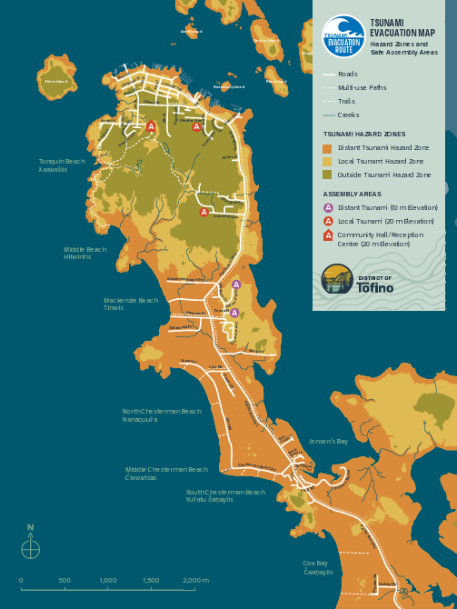
- Know where to bounce to. Look at the evacuation map now…not then. In the event of a tsunami warning, evacuate to the Tofino Community Hall and Emergency Operations Centre. You can see the tsunami hazard zone in the map below.
- Do not return to low-lying areas to gather belongings after waves recede. Emergency officials will let you know when it is safe.
- We all know emergencies happen, but we rarely think it’s going to happen to us. For detailed information on how to be prepared, visit The District of Tofino Emergency Preparedness